
The draining of Lake Kopaida (Lake Copais) in Boeotia, north of Athens, was among the most ambitious land reclamation projects of ancient Greece and antiquity.
Ancient Greeks responded to the constant threat of flooding, the destruction of settlements, and the challenges of water management by draining the lake.
The legendary flood of Ogyges, said to have submerged vast parts of Boeotia, including Athens and Eleusis, was, according to tradition, caused by the overflowing of Lake Kopaida.
Another legend was that the lake came into being when the hero Heracles flooded the area by digging out a river, the Cephissus, which poured into the basin. Polyaenus explains that he did this because he was fighting the Minyans of Orchomenus: they were dangerous horseback fighters, and Heracles dug the lake in order to unhorse them.
The travel writer Pausanias and the 5th-century BC comic playwright Aristophanes record that in antiquity, Lake Kopaida was known for its fish, especially the eels.
The myth credits the ancient Minyans of Orchomenus with constructing the first drainage and water management works to reclaim and protect the land.

Today, the Kopaida basin is a fertile plain, a transformation that began in modern times between 1880 and 1930 with the complete drainage of the lake. But the story of taming its waters stretches back thousands of years. In fact, the earliest efforts to drain Lake Kopaida were during the Mycenaean era, when the ancient engineers undertook a massive hydraulic enterprise.
“They reshaped the perimeter of the lake by redirecting two rivers—the Boeotian Cephissus and the Melas—into the natural sinkholes (katavothres) on the lake’s edges, allowing excess water to escape to the sea,” Evi Tsota, an archaeologist at the Ephorate of Antiquities of Boeotia told the Athens-Macedonia News Agency recently.
“To achieve this, they dug deep canals, constructed embankments, and built reservoirs to store water during dry periods. The goal was clear: to turn the flood-prone basin into fertile, habitable land.”
She noted that one of the most remarkable remnants of this project is the northern drainage canal, an engineering marvel stretching approximately 25 kilometers from Orchomenos to modern-day Kastro. There, it split in two, directing water toward the natural sinkholes.
“A massive mound, 3 meters high and 30 meters wide, was constructed alongside the canal,” Tsota said. “To protect it from erosion, a robust Cyclopean wall—2.5 meters thick—was built along both sides. This served not only to contain the water but also as a safe route for people and goods.”

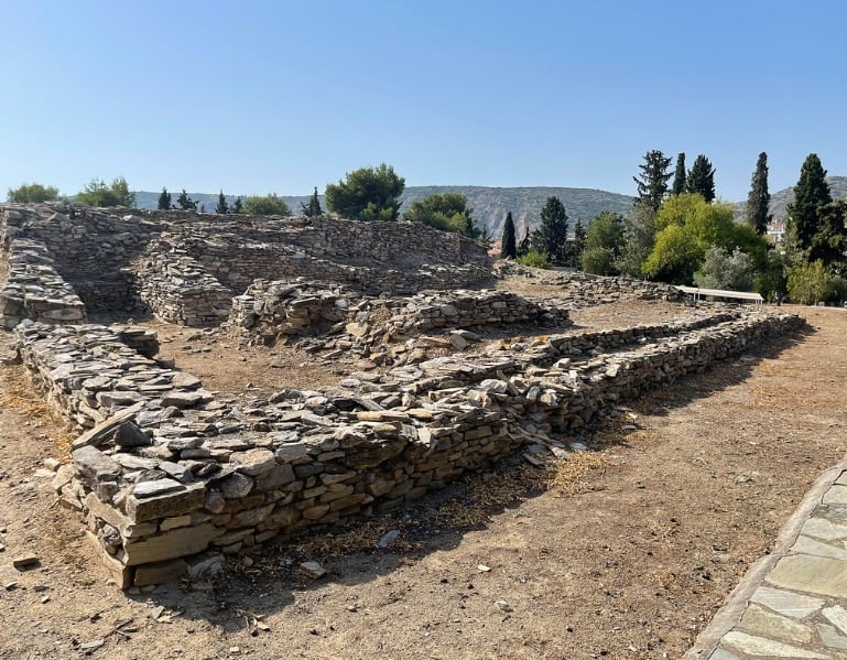
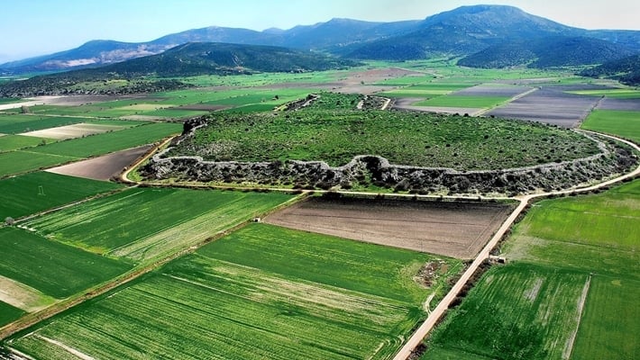
The fortress of Gla, one of the most impressive Mycenaean strongholds, was strategically built on a prominent limestone outcrop at the eastern edge of the tectonic basin that once formed Lake Kopaida. Although its ancient name remains unknown, Gla is considered the second major center of the region after Orchomenos, reflecting its significant role in the Mycenaean period.
During times when the Kopaida basin filled with water, the rock of Gla emerged as an islet, isolated by the surrounding lake. It was inhabited during the 13th century BCE, a period of extensive Mycenaean engineering. With the advent of the massive drainage project—one of the most ambitious land reclamation efforts of the ancient world—the artificial redirection of rivers and creation of canals transformed the lake into a fertile plain, making Gla once again accessible by land.
But the story of Kopaida’s drainage efforts didn’t end in prehistory. Centuries later, during the reign of Alexander the Great (335–331 BC), new drainage works were carried out. These reused elements of the Mycenaean system while also adding new central canals.
The Roman period also left a lasting mark. In the early 2nd century AD, the Roman Emperor Hadrian personally addressed the region’s flooding problems. Archaeological findings from 1920 near Koroneia in Boeotia unearthed inscriptions carved into marble pillars—one of which is now housed at the Archaeological Museum of Thebes—containing letters from Hadrian himself. In these, he discusses the need for river regulation and the construction of ditches and embankments.
In his first letter (125 AD), Hadrian pledges 65,000 denarii from the imperial treasury for flood control efforts and allows the local residents to select the engineers. A decade later, in a second letter (135 AD), he assigns his trusted friend Aemilius Iugu to oversee the regulation of the Phalarus River.
A third letter confirms the project’s completion and emphasizes the importance of ongoing maintenance, warning that any damage must be repaired at the culprit’s expense—and failure to do so would result in a fine of 1,500 denarii to be paid by the city.
These Roman interventions marked the final ancient chapter in the region’s centuries-long battle with water.
“The Roman drainage works brought lasting agricultural prosperity and continued a long tradition of human ingenuity in the face of environmental challenges,” Tsota stressed.
In gratitude, the citizens of Koroneia honored Hadrian with a statue, now preserved at the Archaeological Museum of Thebes—standing as a timeless symbol of the enduring relationship between people and the land they fight to preserve.